Mapping the Uncharted: Unveiling the Fascinating World of Map Size Comparisons
In the vast expanse of the world, maps have long been a trusted companion for travelers, explorers, and geographers alike. A map's scale is often the first thing that comes to mind when considering its significance, yet it is frequently overlooked as a fundamental aspect of cartography. Map size comparisons, in particular, have piqued the interest of researchers, educators, and enthusiasts, as they offer a fascinating glimpse into the world's vastness and the way it has been represented throughout history.
From the early days of hand-drawn cartography to the present day's sophisticated digital mapping, the scale of maps has undergone significant transformations. The Industrial Revolution marked the beginning of mass production, making it possible to create accurate and detailed maps on a larger scale. However, even the most modern maps are subject to limitations, as they are ultimately based on the inherent assumptions and biases of their creators. This raises the question: how can we truly comprehend the world's vastness when our understanding is shaped by the maps we use to navigate it?
To explore this inquiry, we must delve into the world of map size comparisons. From the intricacies of ancient cartography to the latest advancements in digital mapping, we will embark on a geographic odyssey that will challenge our perceptions of space and scale.
A Brief History of Map Size Comparisons
Maps have been used for navigation and representation for thousands of years, with the earliest known maps dating back to ancient civilizations in Mesopotamia, Egypt, and Greece. These early maps were often hand-drawn and presented on papyrus or stone tablets. As trade and exploration increased, so did the need for more accurate and detailed maps. The development of cartography as a distinct field began during the Renaissance, with cartographers like Gerardus Mercator and Abraham Ortelius making significant contributions to the art.
Scale, Proportion, and Perspective
Maps are inherently two-dimensional representations of a three-dimensional world. As a result, they rely on scale, proportion, and perspective to convey the relative sizes and relationships between geographical features. Scale, in particular, is a crucial element in map-making, as it determines the accuracy with which features are represented. However, scale is not always a straightforward concept, and its representation can be misleading.
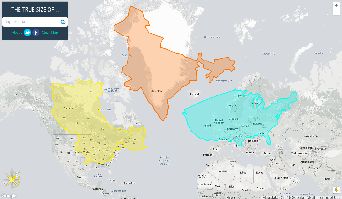
- Different map projections, such as the Mercator projection, can distort the size and shape of features, leading to inaccurate representations of distance and scale.
- The use of perspective in map-making can create an optical illusion, making features appear closer or farther away than they actually are.
- Scale can also be used to manipulate the viewer's perception, with maps featuring exaggerated or reduced scales to convey specific information or create a particular effect.
The Problem of Projection
One of the most significant challenges in map-making is the problem of projection. Cartographers must choose a projection that balances the need for accurate representation with the limitations of two-dimensional representation. Different projections have distinct advantages and disadvantages, and the choice of projection can significantly impact the accuracy of map size comparisons.
- Mercator projection: This projection preserves angles and shapes well, making it useful for navigation, but distorts the size and shape of features near the poles.
- Gall-Peters projection: This projection preserves the true shape and size of features, but distorts angles and shapes near the equator.
- Robinson projection: This projection is a compromise between the Mercator and Gall-Peters projections, offering a balance between accuracy and readability.
The Impact of Technology on Map Size Comparisons
The advent of digital mapping has revolutionized the field of cartography, offering new tools and techniques for creating accurate and detailed maps. Digital mapping has also enabled the creation of maps on a much larger scale, making it possible to visualize and compare features in greater detail than ever before.
- High-resolution imagery: Satellites and aerial photography have provided unprecedented levels of detail, allowing for the creation of maps with features as small as buildings and roads.
- Digital elevation models: These models use a combination of satellite imagery and terrain data to create accurate representations of the Earth's surface, enabling the creation of detailed maps of complex terrain.
- Geographic information systems (GIS): GIS software allows users to analyze and visualize spatial data, making it possible to compare and contrast features across different scales and resolutions.
The Future of Map Size Comparisons
As technology continues to advance, we can expect significant improvements in the creation and analysis of maps. Emerging trends and technologies include:
- Artificial intelligence (AI) and machine learning (ML): These technologies are being used to improve the accuracy and efficiency of map-making, as well as to create new types of maps and visualizations.
- Virtual and augmented reality (VR/AR): These technologies are being used to create immersive and interactive maps, enabling users to explore and interact with maps in new and innovative ways.
- Crowdsourced mapping: This approach involves crowdsourcing data and contributions from a large number of users, enabling the creation of maps with unprecedented levels of detail and accuracy.
Conclusion
Map size comparisons offer a fascinating window into the world's vastness and the way it has been represented throughout history. By exploring the intricacies of ancient cartography, the challenges of map-making, and the latest advancements in digital mapping, we can gain a deeper understanding of the complex relationships between scale, proportion, and perspective. As technology continues to evolve, we can expect significant improvements in the creation and analysis of maps, enabling us to visualize and explore the world in new and innovative ways.
Oksana Glamour Official
Pamibaby
Kaitlynkrems Fans
Article Recommendations
- Maureen Bates
- Google My Business Ranking Checker
- Are Mykie And Anthony Padillatillating
- Paige Vanzant
- Michael Galeotti
- Amariah Moralesd
- Is Kevin Costnertill Alive
- Does John Heilemann Have Cancer
- Whitney Mathers
- Cyril Ramaphosa Children


